Pages

Saturday, March 31, 2012

Angola


Angola, officially the Republic of Angola (Portuguese: República de Angola, Kikongo, Kimbundu, Umbundu: Repubilika ya Ngola), is a country in southern Africa bordered by Namibia on the south, the Democratic Republic of the Congo on the north, and Zambia on the east; its west coast is on the Atlantic Ocean with Luanda as its capital city. The exclave province of Cabinda has borders with the Republic of the Congo and the Democratic Republic of the Congo.


The Portuguese were present in some—mostly coastal—points of the territory of what is now Angola, from the 16th to the 19th century, interacting in diverse ways with the peoples that lived there. In the 19th century they slowly and hesitantly began to establish themselves in the interior. Angola as a Portuguese colony encompassing the present territory was not established before the end of the 19th century, and "effective occupation", as required by the Berlin Conference (1884) was achieved only by the 1920s. Independence was achieved in 1975, after a protracted liberation war. After independence, Angola was the scene of an intense civil war from 1975 to 2002. The country has vast mineral and petroleum reserves, and its economy has grown on average at a two-digit pace since the 1990s, and especially since the end of the civil war. However, its level of human development is rather low, and its life expectancy and infant mortality rates are both among the worst-ranked in the world.
Angola's motto is Virtus Unita Fortior, a Latin phrase meaning "Virtue is stronger when united." The executive branch of the government is composed of the President, the Vice-Presidents and the Council of Ministers. For decades, political power has been concentrated in the Presidency. Angola is divided into eighteen provinces (províncias) and 163 municipalities. Governors of the 18 provinces are appointed by and serve at the pleasure of the president. The Angolan Armed Forces (AAF) is headed by a Chief of Staff who reports to the Minister of Defense. There are three divisions—the Army (Exército), Navy (Marinha de Guerra, MGA), and National Air Force (Força Aérea Nacional, FAN). Total manpower is about 110,000.


The Emblem of Angola is the national emblem. It reflects the recent past of the new nation. There is heavy Marxist imagery found on the device, expanded from what is found on the national flag. In the past, Angola has used coats of arms to represent the nation.
In the center is a machete and hoe, representing the revolution through which the nation gained independence, and the importance of agricultural workers. Above both emblems is a star that is often found in many socialist images. The star is taken to represent progress. The rising sun is the traditional symbol of a new beginning. These emblems are all enclosed within a circle formed by a half cog-wheel that represents the industrial workers, and a half vine of coffee and cotton leaves that represents the coffee resp. cotton industry. At the bottom is an open book that is to represent education. A banner reads "Republic of Angola" at the bottom, in Portuguese.


As always, the above designs are available on a limited number of selected quality products via my “World Heraldry” galleries at Zazzle. You may simply follow the direct links in the article to navigate to the corresponding galleries.
I will also make my designs available free of charge for non-commercial use to any government and military officials of the corresponding countries, as well as for non-commercial and personal use, such as school projects, presentations, forum avatars to businesses and individuals.


The above information provided in part by Wikipedia, The Heraldry Society, Global Security, and official websites of the above-mentioned countries. 


Friday, March 30, 2012

Andorra


Andorra, officially the Principality of Andorra (Catalan: Principat d'Andorra), also called the Principality of the Valleys of Andorra, (Catalan: Principat de les Valls d'Andorra), is a small landlocked country in southwestern Europe, located in the eastern Pyrenees mountains and bordered by Spain and France. It is the sixth smallest nation in Europe having an area of 468 km2 (181 sq mi) and an estimated population of 84,082 in 2009. Its capital, Andorra la Vella, is the highest capital city in Europe, being at an elevation of 1023 metres. The official language is Catalan, although Spanish, Portuguese, and French are also commonly spoken.


The Principality was formed in 1278. The role of monarch is exercised jointly by the two co-princes, the Bishop of Urgell and the current President of France. Andorra is a prosperous country mainly because of its tourism industry, which services an estimated 10.2 million visitors annually, and also because of its status as a tax haven. It is not a member of the European Union, but the euro is the de facto currency. The people of Andorra have the 4th highest human life expectancy in the world — 82 years at birth. Given its relative isolation, Andorra has existed outside the mainstream of European history, with few ties to countries other than France and Spain. In recent times, however, its thriving tourist industry along with developments in transport and communications have removed the country from its isolation. Its political system was modernized in 1993, when it became a member of the United Nations and the Council of Europe. The politics of Andorra take place in a framework of a parliamentary representative democracy, whereby the Prime Minister of Andorra is the head of government, and of a pluriform multi-party system. Andorra maintains a small Army, and all able-bodied men who own firearms must serve. The Army is unique in that all men are treated as officers. The Army's main responsibility is to present the national flag at ceremonies. The country also has an internal police force. Responsibility for defending Andorra rests primarily with France and Spain. Andorra is a full member of the United Nations, the OSCE, and has a special agreement with the European Union.
The coat of arms of Andorra has existed for centuries. It supposedly violates the rule of tincture. This coat of arms has been the national coat of arms of Andorra since 1969. Below the shield arms stands Andorra's national motto Virtus Unita Fortior (Latin for United virtue is stronger). The coat of arms also appears on the flag of Andorra.


As always, the above designs are available on a limited number of selected quality products via my “World Heraldry” galleries at Zazzle. You may simply follow the direct links in the article to navigate to the corresponding galleries.
I will also make my designs available free of charge for non-commercial use to any government and military officials of the corresponding countries, as well as for non-commercial and personal use, such as school projects, presentations, forum avatars to businesses and individuals.


The above information provided in part by Wikipedia, The Heraldry Society, Global Security, and official websites of the above-mentioned countries. 


Thursday, March 29, 2012

Algeria


Algeria (Arabic: الجزائر‎, al-Jazā'ir; Berber and Algerian Arabic: Dzayer or Ldzayer, French: Algérie), officially the People's Democratic Republic of Algeria (Al Jumhuriyah al Jazairiyah ad Dimuqratiyah ash Shabiyah), also formally referred to as the Democratic and Popular Republic of Algeria, is a country in the Maghreb region of Northwest Africa with Algiers as its capital.
In terms of land area, it is the largest country in Africa and the Arab World (since South Sudan gained independence from Sudan in July 2011), and also of the countries bordering the Mediterranean Sea; it is also the tenth-largest country in the world. The country is bordered in the northeast by Tunisia, in the east by Libya, in the west by Morocco, in the southwest by Western Sahara, Mauritania, and Mali, in the southeast by Niger, and in the north by the Mediterranean Sea. Its size is almost 2,400,000 square kilometres (926,645 sq mi) with an estimated population of 36.3 million as of 2011. Its southern part includes a significant part of the Sahara. To the north, the Tell Atlas form with the Saharan Atlas, further south, two parallel sets of reliefs in approaching eastbound, and between which are inserted vast plains and highlands. Both Atlas tend to merge in eastern Algeria. The vast mountain ranges of Aures and Nememcha, occupy the entire north eastern Algeria and are delineated by the Tunisian border. The highest point is Mount Tahat (3,003 m). Algeria is divided into 48 provinces (wilayas), 553 districts (daïras) and 1,541 municipalities (baladiyahs). Each province, district, and municipality is named after its seat, which is usually the largest city.
 Algeria is a member of the African Union, the Arab League, OPEC and the United Nations. The country is also a founding member of the Arab Maghreb Union.
The national emblem of Algeria (Arabic: شعار الجزائر الوطني‎) is the seal used by the government, as other states use coats of arms. The current form of the emblem was adopted in 1976, but was only differentiated from previous one by the changing of the motto from French to Arabic. Contained on the emblem is the crescent that is also found on the flag of Algeria, and is a symbol of Islam. The text that rings the emblem says in Arabic: الجمهورية الجزائرية الديمقراطية الشعبية ("The People's Democratic Republic of Algeria", the country's official name). The hand of Fatima, a traditional symbol of the region, appears in front of the Atlas Mountains, below a rising sun representing a new era. Buildings stand for industry and plants for agriculture.


As always, the above designs are available on a limited number of selected quality products via my “World Heraldry” galleries at Zazzle. You may simply follow the direct links in the article to navigate to the corresponding galleries.
I will also make my designs available free of charge for non-commercial use to any government and military officials of the corresponding countries, as well as for non-commercial and personal use, such as school projects, presentations, forum avatars to businesses and individuals. 


The above information provided in part by Wikipedia, The Heraldry Society, Global Security, and official websites of the above-mentioned countries. 


Tuesday, March 27, 2012

Albania


Albania, officially known as the Republic of Albania is a country in Southeast Europe. It is bordered by Montenegro to the northwest, Kosovo to the northeast, the Republic of Macedonia to the east and Greece to the south and southeast. It has a coast on the Adriatic Sea to the west, and on the Ionian Sea to the southwest. It is less than 72 km (45 mi) from Italy, across the Strait of Otranto which links the Adriatic Sea to the Ionian Sea. Albania is a member of the UN, NATO, the Organization for Security and Co-operation in Europe, Council of Europe, World Trade Organisation, Organisation of Islamic Cooperation and one of the founding members of the Union for the Mediterranean. Albania has been a potential candidate for accession to the European Union since January 2003, and it formally applied for EU membership on 28 April 2009.
Albania is a parliamentary democracy with a transition economy. The Albanian capital, Tirana, is home to approximately 600,000 of the country's 3,000,000 people. Free-market reforms have opened the country to foreign investment, especially in the development of energy and transportation infrastructure. Albania is divided into 12 administrative counties (Albanian: qark or prefekturë). These counties include 36 districts (Albanian: rreth) and 373 municipalities (Albanian: bashki or komunë). 72 municipalities have city status (Albanian: qytet). There are overall 2980 villages/communities (Albanian: fshat) in all Albania. Each district has its council which is composed of a number of municipalities. The municipalities are the first level of local governance, responsible for local needs and law enforcement.
The Albanian republic is a parliamentary democracy established under a constitution renewed in 1998. The Euro-Atlantic integration of Albania has been the ultimate goal of the post-communist governments. Albania's EU membership bid has been set as a priority by the European Commission.
Albania, along with Croatia, joined NATO on 1 April 2009, becoming the 27th and 28th members of the alliance.
The coat of arms of Albania is an adaptation of the flag of Albania. It is based on the seal of Gjergj Kastriot Skanderbeg. The emblem above the head of the two-headed eagle is the helmet of Skanderbeg, surmounted with billy goats' horns. The flag of Albania (Albanian: Flamuri i Shqipërisë) is a red flag, with a silhouetted black double-headed eagle in the centre. The double-headed eagle is the national symbol of the Albanians and was used for heraldic purposes during the Middle Ages by a number of Albanian noble families, including the Kastrioti, whose most famous member was George Kastriot Skanderbeg. The Kastrioti's coat of arms, depicting a double-headed eagle on a red field, became famous when he led a revolt against the Ottoman Empire that resulted in brief independence for some regions of Albania from 1443 to 1478. The double-headed eagle on the flag is borrowed from the banner of the Byzantine Empire. The Albanian flag has gone through a number of changes over the years as different regimes have modified it. During the reign of King Zog (r. 1928–1939), a crown was added to the flag and was replaced by two axes during the Italian occupation of Albania. After World War II, the communist regime added a five-pointed golden star, which was removed on 7 April, 1992 after the communist government in Albania collapsed.

As always, the above designs are available on a limited number of selected quality products via my “World Heraldry” galleries at Zazzle. You may simply follow the direct links in the article to navigate to the corresponding galleries.
I will also make my designs available free of charge for non-commercial use to any government and military officials of the corresponding countries, as well as for non-commercial and personal use, such as school projects, presentations, forum avatars to businesses and individuals. 


The above information provided in part by Wikipedia, The Heraldry Society, Global Security, and official websites of the above-mentioned countries. 

Monday, March 26, 2012

Afghanistan


Afghanistan (Persian/Pashto: افغانستان), officially the Islamic Republic of Afghanistan, is a landlocked country located in the centre of Asia, forming South Asia, Central Asia and the Middle East. With a population of about 29 million, it has an area of 647,500 km2 (250,001 sq mi), making it the 42nd most populous and 41st largest nation in the world. It is bordered by Pakistan in the southeast, Iran in the west, Turkmenistan, Uzbekistan and Tajikistan in the north, and China in the far northeast. The territory that now forms Afghanistan has been an ancient focal point of the Silk Road and human migration. Archaeologists have found evidence of human habitation from as far back as 50,000 BC. Urban civilization may have begun in the area as early as 3,000 to 2,000 BC.
The country sits at an important geostrategic location that connects the Middle East with Central Asia and the Indian subcontinent, which has been home to various peoples through the ages. The land has witnessed many military conquests since antiquity, notably by Alexander the Great, Chandragupta Maurya, and Genghis Khan. It has also served as a source from which local dynasties such as the Greco-Bactrians, Kushans, Saffarids, Ghaznavids, Ghorids, Timurids, Mughals and many others have established empires of their own.
The political history of modern Afghanistan begins in 1709 with the rise of the Pashtuns, when the Hotaki dynasty was established in Kandahar followed by Ahmad Shah Durrani's rise to power in 1747.  The capital of Afghanistan was shifted in 1776 from Kandahar to Kabul and part of the Afghan Empire was ceded to neighboring empires by 1893. In the late 19th century, Afghanistan became a buffer state in the "Great Game" between the British and Russian empires. Following the third Anglo-Afghan war and the signing of the Treaty of Rawalpindi in 1919, the nation regained control over its foreign policy from the British.
After the 1978 Marxist revolution, the Soviet Union began a 10-year war in which over a million Afghans lost lives. The mujahidin insurgency generated by the Marxist government and the Soviet invasion signaled the first sustained entry of Islam into Afghan politics as the religion served as a force to unify the tribally divided multiethnic population. This was followed by the Afghan civil war (1992–1996), the rise and fall of the extremist Taliban government and the 2001 war.
Afghanistan is administratively divided into 34 provinces (wilayats), with each province having its own capital and a provincial administration. The provinces are further divided into about 398 smaller provincial districts, each of which normally covers a city or a number of villages. Each district is represented by a district governor.
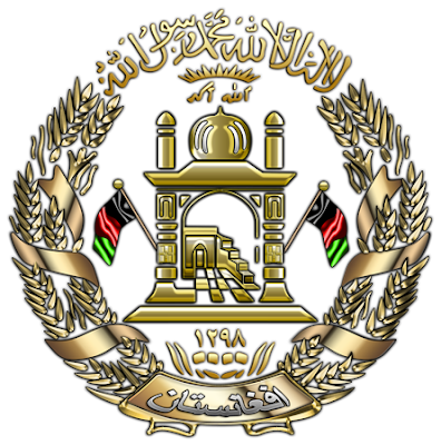
The national emblem of Afghanistan has appeared in some form on the flag of Afghanistan since the inception of that nation.
The latest incarnation of the coat of arms has the added inscription of the shahadah in Arabic at the top. Below it is the image of a mosque with a mehrab that is facing Mecca with a prayer mat inside. Attached to the mosque are two flags, taken to stand for flags of Afghanistan. Beneath the mosque is an inscription that states the name of the nation. Around the mosque is a garland. The emblem of Afghanistan bears the Islamic calendar year 1298 (1919 in the Gregorian calendar), the year Afghanistan gained independence from the British Empire.

As always, the above designs are available on a limited number of selected quality products via my “World Heraldry” galleries at Zazzle. You may simply follow the direct links in the article to navigate to the corresponding galleries.
I will also make my designs available free of charge for non-commercial use to any government and military officials of the corresponding countries, as well as for non-commercial and personal use, such as school projects, presentations, forum avatars to businesses and individuals. 


The above information provided in part by Wikipedia, The Heraldry Society, Global Security, and official websites of the above-mentioned countries. 

Foreword

This project was inspired by one of my earlier projects, called “Small World”. Since I was always fascinated with heraldic images, the very logical step was to explore state heraldry, such as coats of arms of different countries. The most captivating feature of such images was their ability to convey essence of the whole country in a very precise, compact and yet, visually striking form.  However, my earlier “Small World” project was not systematic, the order and choice of countries was somewhat erratic, and not quite unified in terms of styles and artistic approaches. I always felt that this could be done differently, bigger and better. This is how the idea of the “World Heraldry 3D” project was born. The plan was to recreate and gather under one roof state heraldry images of all the existing modern countries of the world, as well some of the historical ones, utilizing my unique Multi-Layer Enhancement & Texturing Technique (M-LETT 2.5D), which helps me to highlight the true beauty of such images. Not a single country missed, all in alphabetical order. For each country would be represented by four distinct designs:  a coat of arms, a map overlaid with country flag, and two variations of the above-mentioned designs combined, as you can see in the Canada’s example below.
Also, each article will have a brief intro about the country itself, and wherever possible, some background on the coat of arms. I will also be giving highlights on some of my techniques and tools used to create each design. In this project I will be relying on the “List of sovereign states” provided by Wikipedia, as well as on some other sources.  Quoting Wikipedia, “…Compiling a list such as this can be a difficult and controversial process, as there is no definition that is binding on all the members of the community of nations concerning the criteria for statehood. For more information on the criteria used to determine the contents of this list, please see the criteria for inclusion. At the time of this writing, the list contains 206 entries. As soon as the entire list of sovereign states is covered, I will move to the next stage of the project, which will involve all countries and territories, which were not included in the above list. When Stage II is done, I will be moving to Stage III, covering administrative divisions, such as states, provinces, republics, etc., eventually moving down to a town/city level. 

As always, the designs will be available on a limited number of selected quality products via my “World Heraldry” galleries at Zazzle. You may simply follow the direct links in the article to navigate to the corresponding galleries.
I will also make my designs available free of charge for non-commercial use to any government and military officials of the corresponding countries, as well as for non-commercial and personal use, such as school projects, presentations, forum avatars to businesses and individuals. 


Obviously, the project is fairly massive and extremely exciting, and I am definitely in it for a long haul. So, stay tuned and visit often…